Then and Now: Mind-Blowing Photographs of How Historic Locations Have Changed

Then and Now: Mind-Blowing Photographs of How Historic Locations Have Changed

Aimee Heidelberg - April 14, 2023

Buildings are among the greatest silent storytellers. Seeing historic places then and now shows how these places are a constant in a rapidly changing world. It is a story that never ends. In Rome, tourists gaze at the same Doric columns that Julius Caesar and Augustus touched. Visitors to Hiroshima see a modern city built on the remains of a shattered community. Historic images hold ‘hidden’ information about its subject. Look around the subject of the image. The context of the site has changed, the world around may be completely different. Sometimes photos show how things haven’t changed, which is just as important – it shows how the community honors a place, and the care it takes to preserve it. There are online communities dedicated to documenting sites, photographing them as they evolve. These histories are vital to understanding place, local values, and the impact of world events on local landmarks.

Then and Now: Mind-Blowing Photographs of How Historic Locations Have Changed
Arc de Triomphe, 1920 (l) and 2015(r). nwolpert, re.photos.

Arc de Triomphe, Paris, France, 1920 and 2015

The Arc De Triomphe was a love letter from Napoleon to his soldiers after the Battle of Austerlitz. When he returned to France, he decreed the Arc built to honor the brave men of his army. The Arch of Titus in Rome inspired the design, fitting Napoleon’s love of classical architectural forms. After some debate about its placement, it sits at the hub of the Champs de Elysees. It sits at the hub of 12 roads, including wide, scenic boulevards, giving visitors a sweeping view of Paris. King Louis Philippe, after making his own alterations, dedicated the Arc de Triomphe in 1836. The modern image shows a busy traffic circle around the Arc. “Paris est Charlie,” temporarily projected on the Arc is a response to eight staff members at Charlie Hebdo magazine killed in a 2015 extremist attack.

Then and Now: Mind-Blowing Photographs of How Historic Locations Have Changed
Avenue d’léna, Champs de Mars, Paris, 1900 (l), and 2016 (r). nwolpert, re.photos, Public Domain (l), CC BY-SA 4.0.

Avenue d’léna, Champs de Mars, Paris, France, then and now

The Eiffel Tower started as a monument centerpiece for the 1889 Paris World’s Fair. When the fair returned to Paris in 1900, it again featured the Eiffel Tower as its centerpiece, but for the first and only time, fair planners coated it with a yellow-gold paint. Fifty million visitors descended on the fairgrounds to see what the 83,000 exhibitors had to show them. There is a conspicuous addition to the scene, though. A Ferris Wheel is visible to the left of the Eiffel Tower in the 1900 image. The Ferris Wheel was a way to “Out-Eiffel Eiffel” at the 1893 World’s Fair in Chicago, Illinois. It proved so popular it became a Midway staple at fairs all over the world, including the 1900 Paris Exhibition. By 2016, the Paris Exhibition was a memory, but the tree-lined street lined with historic architecture stays, as does the Eiffel Tower.

Then and Now: Mind-Blowing Photographs of How Historic Locations Have Changed
Barong Dance at East Side of Pura Gunung Kawi, 1925 (l), and 2016 (r). Lena, re.photos.

Barong Dance at Gunung Kawi, Tampaksiring, Indonesia, 1925 and 2016

In Tampaksiring, near Bali in Indonesia, lies a 11-th century temple complex with monuments carved into the cliff. Often compared to Egypt’s Valley of the Kings, the site features the monuments of King and religious scholar Udayana and his queens, children, and concubines. Ten Gunung Kawi candi (shrines) stand in honor of their memory, nestled into niches cut seven meters (23 feet) high. The candi look like portals, but instead of leading visitors inside, there is a small place beneath each one leading to a small chamber that holds symbolic offerings. The image from 1925 shows dancers telling the mythological story of Barong. Their dance depicts Barong, a lion-ish symbol of Good. Dances often depict battles with Rangda, the symbol of Evil. Today, Gunung Kawi is still a sacred site, but it is open for public visits. In 2017, President Barack Obama visited the temple during his trip to Bali.

Then and Now: Mind-Blowing Photographs of How Historic Locations Have Changed
Beverly Hills Hotel, 1918 (l) and 2018 (r). AnthonyRossStudio, re.photos. Public Domain (l), CC BY 4.0 (r)

Beverly Hills Hotel, Beverly Hills, USA, 1918 and 2018

Before there was a Beverly Hills, there was the Beverly Hills Hotel. In 1907, Burton Green created the Beverly Hills subdivision. Margaret Anderson set up the hotel as somewhere to stay as they scoped the subdivision for property. The Beverly Hills Hotel opened in 1912, while the city would not incorporate until 1914. Mary Pickford and Douglas Fairbanks, two of the biggest celebrities at the time, constructed their home, “Pickfair,” near the hotel. The Beverly Hills Hotel hosted waves of celebrities, from Charlie Chaplin, Marilyn Monroe, John Lennon, and royalty from around the world. The Sultan of Brunei bought the property in 1986. In 2014, he sent a wave of protest into the hotel after revising Brunei’s laws to include elements of Sharia law, a move protested by the United Nations Human Rights Council. The Sultan has yet to give up ownership of the hotel.

Then and Now: Mind-Blowing Photographs of How Historic Locations Have Changed
Black Hills, USA, 1874 (l) and 2021 (r). robertwellmancampbell, re.photos. Public Domian (l), CCO 1.0 (r)

Black Hills, South Dakota, USA, then and now

In the 1870s, the Black Hills of South Dakota was a gateway to the American West. The 1874 image shows a wagon train moving single file across the landscape. According to photographer robertwellmancampbell, “…the wagon train was stopped for a corduroy “bridge” to be laid downstream (i.e. further left).” A corduroy road or bridge is made of logs placed across the width of a path, usually to help vehicles, livestock, and travelers traverse swampy or wet lands without getting stuck. This wagon train was part of the Black Hills Expedition of 1874, led by General George Custer and one of the last Gold Rush expeditions of the era. It is considered one of the “best documented” expeditions in the Old West, with explorers keeping journals, filing reports, and photographer W.H. Illingworth taking photographs. The 2021 image shows how close the modern road follows the path of the Custer wagon train.

Then and Now: Mind-Blowing Photographs of How Historic Locations Have Changed
Cabinet Building Reykjavik, 1913 (l) and 2019 (r). nwolpert, re.photos. CC BY-SA 4.0

Cabinet Building, Reykjavik, Iceland, 1913 and 2019

In 1913, a man was leisurely rowing his boat, decorated with a blue and white flag, around the Reykjavik harbor. Although Iceland had its own constitution by 1874, they functioned under Danish rule. The boater’s flag was a symbol of Icelandic independence. The chief of a Danish man-o’-war stopped the boater, telling him he could not fly the Icelandic flag. Icelandic Parliament declared that not only was the arrest unwarranted, and insisted only the Icelandic flag could fly in the country. The group in the 1913 photo showed up to the Cabinet Building to protest the Danish military’s action. Denmark held the nation until Danish occupation by German forces in 1940. Iceland formally achieved the independence they had so long desired in 1944. The modern image shows the building nearly the same, but the statue has changed from Danish King Christian IX to Hannes Hafstein, first Prime Minister of Iceland.

Then and Now: Mind-Blowing Photographs of How Historic Locations Have Changed
Calle Valentín Masip en Oviedo, 1980 (l), 2018 )r). alexpoulsen, re.photos. Public domain.

Calle Valentín Masip en Oviedo, 1980 and 2018

The Calle Valentín Masip is a bustling thoroughfare in Oviedo, Spain, connecting the La Argañosa to the city. The 1980 street is flanked by postmodern architecture that hides the scars of Spanish Civil War and the Siege of Oviedo, with the city supporting the Nationalist side, just forty four years before. The road takes its name from Mayor Valentín Masip Acevedo, a champion of public works who helped develop the road into the commercial and residential district seen in both the 1980 and 2018 image. In the thirty-year span between images, the buildings didn’t change much, but the street itself underwent a transformation. Streetscaping trees line the widened sidewalks, supplying shade, a swath of green, and more space to walk. Classical lanterns replaced gooseneck lights. Benches provide some rest for pedestrians. Despite the architecture staying the same, the street became much more pedestrian friendly.

Then and Now: Mind-Blowing Photographs of How Historic Locations Have Changed
Chichen Itza, El Castillo, 1846 (l) and 2005 (r). 1846 image, public domain. 2005 image, Aimee Heidelberg

Chichen Itza, Yucatan Peninsula, Mexico, 1846 and 2005

The stepped pyramid temple, El Castillo, at Chichen Itza is one of the New Seven Wonders of the World, visited by 2.5 million tourists each year. About 50,000 people may have lived in Chichen Itza, with more in its surrounding suburbs at its height in 600 CE. This was a thriving urban center. El Castillo, the highlight of the Chichen Itza site, was the temple of Kulkulkan, a snake-like spirit. It is situated perfectly so twice a year, the pyramid steps cast a shadow that make it look like Kulkulkan was slithering down the pyramid. In the 1400s, the Mayans abandoned Chichen Itza and El Castillo left to ruin, as seen in the 1846 image. After years of cleanup and restoration, Chichen Itza opened to visitors. In the 2005 image, visitors could climb El Castillo. But due to tourist wear and tear, visitors can no longer make the climb.

Then and Now: Mind-Blowing Photographs of How Historic Locations Have Changed
Chrysler Building, 1932 (l) and 2006 (r). 1932 – Library of Congress, Public Domain. 2006, timsdad, CC SA 3.0

Chrysler Building, New York, USA 1932 and 2006

The Chrysler Building, pictured two years after its May 1930 completion, is a wonder of the Art Deco style. From the series of squares and rectangles at its base to the triangles arranged to create arches, it focuses on using geometric forms as architectural art. At 1,048 feet from base to spire, it was the tallest building in the world – for one year, until the Empire State Building took the title in 1931. But the 1932 and 2006 images show much more than the iconic Chrysler building – it shows the evolution of New York City over seventy-four years. The images show the development of New York’s Upper East Side neighborhoods near the Queensborough Bridge. Few of the 1932 buildings are visible, either demolished or overtaken by newer development. Skyscrapers built around the iconic Chrysler Building gets taller seem to swallow up the former “tallest building in the world.”

Then and Now: Mind-Blowing Photographs of How Historic Locations Have Changed
Coliseum interior, 1875 (l) and 2015 (r). Bera, re.photos, CC BY 4.0

Coliseum, Rome, Italy, 1875 and 2015

Rome’s Coliseum has stood for almost two thousand years as a testament to the might of the Roman Empire. It hosted Gladiator games, races, naumachia, and massive public events until 523 CE. When Rome fell, the Coliseum was left to rot. Nature quickly took its toll on the building. Earthquakes in the fifth century CE, fires, and water damage led to deterioration. Dark Ages builders started plundering the stone, marble, and other materials for building projects. Over time, it served as a cemetery, housing, a castle, shops, and altars. Protection of the site started with Pope Benedict XIV prohibited the use of Coliseum stone for other projects in 1744. Pope Pius VII started conservation on the building in 1820. It served as a church until 1870. The Coliseum, a highly popular tourist destination in Rome, once again serves as an arena, with concerts, plays, and other cultural events staged there.

Then and Now: Mind-Blowing Photographs of How Historic Locations Have Changed
Ebenezer Baptist Church, as Dr. Martin Luther King Jr.’s funeral procession started,1968 (l) and 2021 (r). jacobstauff, re.photos. CC BY 4.0

Ebenezer Baptist Church, Atlanta, USA, 1968 and 2021

On April 9, 1968, Ebenezer Baptist Church in Atlanta, Georgia (USA) was swarmed with people paying their respects to Dr. Martin Luther King, Jr. The civil rights activist and Nobel Peace Prize laureate had been assassinated five days before, shocking the nation and leaving a legacy of peaceful activism toward a world of racial equality. King himself delivered the eulogy, through a recording taken during his last sermon at Ebenezer Baptist Church, where he said at his funeral he didn’t want to be remembered for his awards or honors, but that he tried to feed the hungry, be right on the war question (referring to the Vietnam War in the late 1960s), and “love and serve humanity.” The 1968 photo was taken as his funeral procession started. The Ebenezer Baptist Church now stands quietly as a symbol of Dr. King’s work and continues a ministry based in social justice.

Then and Now: Mind-Blowing Photographs of How Historic Locations Have Changed
Eiffel Tower, 1889 (l) and 2016 (r). nwolpert, re.photos. Public domain (l) and CC BY-SA 4.0

Eiffel Tower, Paris, France 1889 and 2016

There are few buildings in the world as iconic as the Eiffel Tower in Paris, France. It was a hit at the 1889 Paris World’s Fair, earning back the cost of its construction from ticket sales in one year. Critics derided the Eiffel Tower as an expensive eyesore at the time, but it inspired later World’s Fair designers to “out-Eiffel Eiffel,” creating a standard for innovative and eye-catching design. The Eiffel Tower was originally slated for dismantling in 1910, but Gustav Eiffel had the foresight to use it as a radio tower, science lab, and semi-secret apartment space, giving it a practical function. This saved the Tower, leading it to serve as a global tourist destination, seen in the modern image. Since its opening in 1889, it has had more than 167 million visitors.

Then and Now: Mind-Blowing Photographs of How Historic Locations Have Changed
Former Japanese Imperial Army 2nd Division, 1920 (l) and 2018 (r). Taureich, re.photos. CC BY 4.0

Former Japanese Imperial Army 2nd Division, 1920 and 2018

The Second Division was headquartered in Aoba Castle (currently on the campus of Tohoku University) in Sendai, Japan. Aoba Castle is an Edo period (1607-1863) complex erected during a period of stability under the bakuhan government system. They shared the headquarters with the 4th, 5th, 16th, 17th, and later the 29th Infantry Regiments. The 1920 image, taken in the years between the Russo-Japanese War (1904-1905) and conflicts with the Soviet Union (starting in 1932), shows the Wakiyagura of Aoba Castle and the Ōtemon Gate. The wakiyagura tower stands, looming over the road in the 2018 picture, United States forces destroyed both buildings in July of 1945, in bombings toward the end of World War II. The rebuilt wakiyagura generated tourist interest in the site, but the modern image shows the gate was not included in the reconstruction.

Then and Now: Mind-Blowing Photographs of How Historic Locations Have Changed
Haliç, Istanbul, 1854 (l) and 2015 (r). SarmuS, re.photos. CC BY 4.0.

Haliç (“The Golden Horn”), Istanbul, Turkey 1854 and 2015

In 1854, Haliç, or the Golden Horn, in Istanbul, was a prime port location due to its lack of tides and currents. It became a center of trade, government, and the Byzantine navy headquarters. Unfortunately, the Golden Horn’s location and growing wealth also made it vulnerable to attack. To protect this valuable port, the city set up the traditional city wall, but added a unique security measure. They placed a massive iron chain that stretched across the waterway, preventing ship passage. The 1854 image shows the riverway flowing past the Blue Mosque, one of the area’s most notable historic buildings, looming over Haliç. Today is area is a popular tourist district, with historic mosques, bazaars, shops, and restaurants. The two images show the growth and expansion of Haliç, with skyscrapers where countryside used to be, but the Blue Mosque still looms large over the city, tying it to its past.

Then and Now: Mind-Blowing Photographs of How Historic Locations Have Changed
Hiroshima, Genbaku Dome, c. 1920s (l) and 2019 (r). (l) Hiroshima City Archives, (r) shankar s. CC BY 2.0

Genbaku Dome/ Peace Dome, Hiroshima, then and now

On August 6, 1945, the United States used the first atomic bomb on the Japanese city of Hiroshima. The only structure in the epicenter area that survived the blast was the Genbaku Dome, pictured before World War II. The building was constructed in 1915 as the Hiroshima Prefectural Products Display Hall, used as a market for locally produced goods from the city and the surrounding prefect. The copper dome and its brick and steel construction made it stand out among a city built mainly of wood. When the bomb went off, it was nearly directly over the dome. The blast instantly killed everyone inside the building. Despite the devastation, the Display Hall’s earthquake-resistant columns withstood the downward forces of the blast. Today, the preserved remains of the dome stand as a memorial, a cry for peace, and the hope that nuclear weapons will never be used again.

Then and Now: Mind-Blowing Photographs of How Historic Locations Have Changed
Japanese troops advancing through Kuala Lumpur, 1942 (l), and 2016 (r). Lena, CC BY-SA 4.0

Japanese troops advancing through Kuala Lumpur, 1942 and 2016

In December 1941, Japan invaded British-held colonies, including Malaya (currently Malaysia). Malaya held rich rubber and tin resources. Britain exported these resources to their allies to help their war efforts, resources Japan wanted to control. Malaya, including the city of Kuala Lumpur, was an important tactical point for Japan’s plans to expand their oil resources and occupied boundaries. Japan’s offensive was successful, as the British had underestimated Japan’s ability to take the country. Officials quickly abandoned Kuala Lumpur. Japanese forces, as seen in the 1942 image, weeded out resistance cells in the city. Japanese forces held the city’s major buildings, such as the train station, government offices, and Pudu Jail. Pudu Jail, used as a POW detention center, was a brutal place full of disease and little food. Kuala Lumpur remained occupied by Japan until September of 1945, when it went back to the British.

Then and Now: Mind-Blowing Photographs of How Historic Locations Have Changed
Los Angeles Public Library. 1971 Library of Congress, Prints & Photographs Division, CA-1937-9 (l). A. Heidelberg, 2019 (r)

Los Angeles Public Library, 1971 and 2019

In the early 1920s, the Los Angeles Public Library was ready to build on the site of the former State Normal School lot one block away from Pershing Square. When the Los Angeles Library Board hired architect Bertrand Goodhue in the mid-1920s, they hoped he would use the Spanish Colonial style he made famous at the 1915 Panama California Exposition. But his style had changed. Goodhue was designing more modern buildings and went with a grand Art Deco form instead. The 1971 photo shows the facade of the library, as visitors enter from Flower Street and move through Maguire Gardens, named after real estate developer Robert Maguire, who helped restore the library building and grounds after arson in 1986. The trees that create a natural vista are most visible in the modern photo, hiding a part of the building but giving visitors a visual cue toward the building entrance.

Then and Now: Mind-Blowing Photographs of How Historic Locations Have Changed
Mont St. Michel 1908 (l) and 2016 (r). Lena, re.photos. Public Domain (l), and CC1.0 (r)

Mont St. Michel, 1908 and 2016

The legend of Mont Saint-Michel starts with a dream. In 708 CE, the Bishop of Avranches, later Saint Aubert, had a dream that Archangel Michael visited him and asked for a sanctuary built in his name. This vision became reality, and by 966, Benedictine monks inhabited an abbey at the top of a hill, welcoming pilgrims and visitors – when they could reach it. Tides cut the hill off from the mainland twice a day when the tide is at its highest. They had to plan their travels to ensure they are on or off the hill before the tide rolled in and it became an inaccessible island. Since 1928, buildings constructed to imitate historic designs fell to ruin. To preserve the original historic atmosphere of the village, the old buildings have been removed. Efforts are underway to conserve the waterways.

Then and Now: Mind-Blowing Photographs of How Historic Locations Have Changed
Nagasaki, before and after the nuclear bombing, August 1945. US National Archives (1945)

Nagasaki, Japan, pre-1945 and post August 9, 1945

In Nagasaki, the change to the urban landscape happened in an instant. The top picture shows a densely built urban community. A river flows through the landscape, the city streets showing the different areas of development. Three days after dropping the bomb on Hiroshima, the United States prepared for its second target, the city of Kokura. Fortunately for Kokura (but unfortunately for another city), Kokura had too much cloud cover to reliably strike; United States forced wanted visual confirmation of the target. Nagasaki became the alternative target. The bomb killed around 80,000 people, with more dying later from the effects of radiation. The devastation extended one mile around, with fires spreading beyond that. Unlike the dome and other modern buildings in Hiroshima, most buildings in Nagasaki were traditional wood frame structures, even the smaller industrial and commercial buildings. None of these survived the blast.

Then and Now: Mind-Blowing Photographs of How Historic Locations Have Changed
Notre-Dame before and after the fire, 2009 (l), and 2019 (r). nwolpert, re.photos. CC BY-SA 4.0

Notre-Dame, Paris, France, 2009 and 2019

The ten-year difference in these photos reflects one of the most devastating blows to the historical community, the Notre Dame fire of 2019. The building survived Huguenot attacks, the French Revolution, World War II, but was severely damaged during a project meant to protect it. The fire severely damaged the roof and destroyed the spire. The spire, however, was not original to the building, it was a mid-1800s replacement. Amazingly, the copper rooster, a symbol of the French people, that sat at the peak of the spire was found and preserved. The “forest,” the beams that made up the attic level, was also destroyed when the juncture of the transept and north transept collapsed. The beams survived eight centuries but are now only a memory. But the main structure, its historic windows, and many of its sacred artifacts were saved from the flames.

Then and Now: Mind-Blowing Photographs of How Historic Locations Have Changed
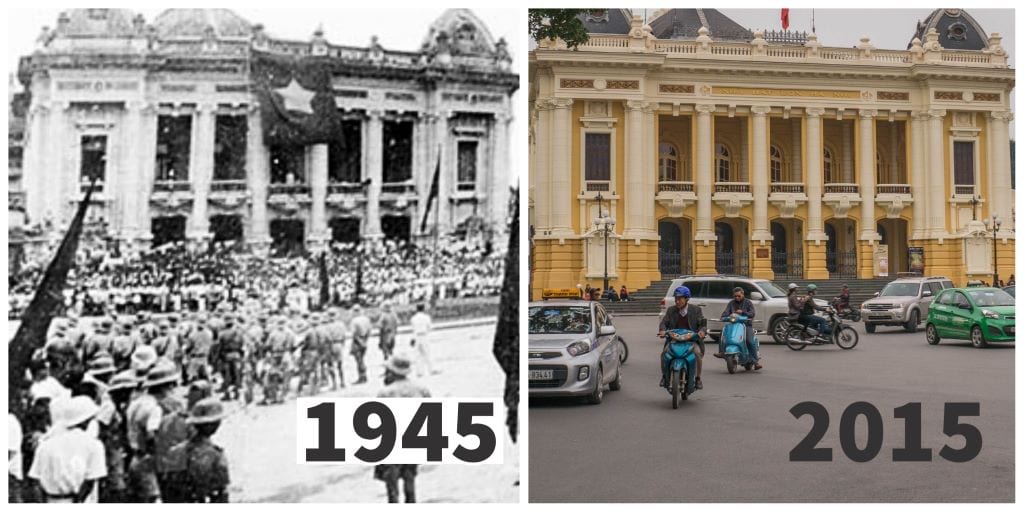
Opera Hanoi during the August Revolution, 1945 (l) and 2015 (r). Lena, re.photos. (l) Public Domain, (r) CC BY-SA 4.0

Opera Hanoi, 1945 and 2015

Since 1858, France occupied Vietnam. This held until 1940, when Japan took over the occupation after France fell to Germany, although Japan kept the French administration in place. In August of 1945, Ho Chi Minh’s Viet Minh forces staged a revolt against these occupying forces, sparking their fight for independence, known as the August Revolution. The 1945 image shows a demonstration of Ho Chi Minh’s forces in front of the Opera Hanoi, a Parisian style opera house built in the early 1900s by the French administration occupying Vietnam. On September 2, 1945, Viet Minh leader Ho Chi Minh declared Vietnam’s independence from France, although France would not acknowledge it. This would spark years of conflict and struggle, drawing in U.S. military forces, and ending with Vietnam united under communist rule. While the Opera Hanoi, pictured in 2015, looks much like it did in 1945, the world around it changed.

Then and Now: Mind-Blowing Photographs of How Historic Locations Have Changed
Pripyat residential unit, c. 1986 (l) and 2006 (r). (l) IAEA Imagebank cc-by-sa-2.0 (r) stahlmandesign (2006) CC BY 2.0

Then and Now: Pripyat, Ukraine

In 1986, the Chernobyl Nuclear Power Plant accident forced the evacuation of nearby Pripyat, Ukraine. Pripyat, was a community of 49,000 established in 1970 to house Chernobyl workers and their families. Officials told residents the evacuation was temporary, and they would be back in a matter of weeks. They would never come back to live there. Pripyat’s buildings serve as an eerie reminder of the once thriving city. While the two images, pre-1986 and 2006 are not the exact same building, they are similar enough to illustrate how nature is reclaiming the city. But Pripyat is not completely abandoned; Public authorities, military, and scientists actively use site. There is still electricity and water running to parts of the city, and the wildlife in the area has thrived. Tours run in Pripyat on a regular basis. It has become a continually active “ghost town.”

Then and Now: Mind-Blowing Photographs of How Historic Locations Have Changed
Rapid City, c. 1913 (l) and 2015 (r). robertwellmancampbell, re.photos. 1913, public domain. 2005, CC 1.0.

Rapid City, USA, 1913 and 2015

Rapid City, South Dakota, was born out of the 1870s Black Hills gold rush. Entrepreneurs saw an opportunity to sell mining and homestead goods to prospectors, setting up a commercial center near the Black Hills. This commercial center, Rapid City, continued to thrive after the gold rush ended in the 1880s. The 1913 image shows a modest community along the eastern edge of the Black Hills. The area became a hub for lumber, mining, agriculture, and tourism. The 2005 image shows some of the historic buildings still standing, but the community has grown, with taller buildings and a denser urban layout. Rapid City today has a thriving tourism industry, serving as a gateway to the Black Hills and famous national landmarks. Visitors come to Rapid City for its easy access to Mount Rushmore, the ongoing Crazy Horse Monument, and the nearby notorious ‘Wild West’ community of Deadwood.

Then and Now: Mind-Blowing Photographs of How Historic Locations Have Changed
Temple of Saturn, Roman Forum, 1866 (l) and 2017 (r). Bera, re.photos. CC BY 4.0

Temple of Saturn, Roman Forum, 1866 and 2017

The Temple of Saturn served a dual purpose in the Roman Forum. It was built to worship Saturn, the god of agriculture and the harvest. It also served as a public treasury (aerarium). The temple ruins shown in these photos are the remains of the third Temple of Saturn on the site. A fire in 283 BCE destroyed an earlier temple on the site. Over time, most of the building had eroded away, leaving only eight Ionic columns to show its former grandeur. Between the 1866 and 2017 photos, archaeologists and architectural historians have taken steps to preserve and stabilize the ruins. One noticeable effort is the bands around the columns to help stabilize the structure. The main changes have taken place around the ruins. A cluster of buildings, which are contemporary to the 1860s, no longer stand in the Forum grounds, revealing more Ancient Roman structures.

Then and Now: Mind-Blowing Photographs of How Historic Locations Have Changed
Royal Street, New Orleans, 1910 (l) and 2019 (r). nwolpert, re.photos. (l and r) CC BY-SA 4.0

Royal Street, New Orleans, USA, 2010 and 2019

New Orleans’s French Quarter is one of the oldest, and most famous, areas of the Crescent City. Royal Street may not have the notoriety of nearby Bourbon Street, but the history, commerce, and historic significance are similar. Royal Street dates to the 1720s, when New Orleans was a center of French trade. By the late 1700s, the city had fallen under Spanish control. The delicate wrought iron balconies reflect the Spanish influence on New Orleans’ architecture. The 1910 picture shows a streetcar line on Royal Street. By 1948, the city replaced most streetcars in the French Quarter with busses. Today, there is no public transit within the French Quarter section of Royal Street, transit stops are along the outside perimeter. Royal Street is open to automobile traffic during the day, but at night, barricades go up; no vehicles allowed. It becomes a busy pedestrian entertainment, shopping, and tourist corridor.

Then and Now: Mind-Blowing Photographs of How Historic Locations Have Changed
Salem Witch House, 1901 (top) and 2013 (bottom). Top, public domain. Bottom, A.Heidelberg, CC-NC 4.0

Salem Witch House, 1901 and 2013

In 1692, Salem, Massachusetts was a terrifying place to be. Anyone, beggars, farmers, wealthy tavern owners, even a minister could be (and were) accused of witchcraft. Salem judges had nineteen people hanged and pressed one to death based on “spectral evidence” provided by a handful of the town’s teen girls. Jonathan Corwin was a judge during the Trials, investigating claims and signing arrest warrants. The Witch House (also known as the Jonathan Corwin House) is the only known remaining building associated with the Trials. Over the centuries, the house underwent radical alterations. In 1856, druggist George Farrington purchased the property and added an apothecary to the front (seen in the 1901 photo). In 1945 the building was moved from its original location to save it from a road project, kick-starting other preservation efforts. The City of Salem bought the house and has restored it back to its 1600s form.

Then and Now: Mind-Blowing Photographs of How Historic Locations Have Changed
Tomb of the Unknown Soldier, Paris, 1920 (l) and 2016 (r). nwolpert, re.photos. CC BY-SA 4.0.

Tomb of the Unknown Soldier, Paris, France, 1920 and 2016

Under the watch of an eternal flame and the shadow of the Arc de Triomphe, the Tomb of the Unknown Soldier lies as a symbol of the soldiers who died in World War I, never to have a tomb under their own names. The 1920 image shows the ceremony and burial of the solider selected to represent these unnamed fallen. War Minister André Maginot asked Auguste Thin, who guarded the coffins of eight Tomb candidates, to select one for the Tomb. Thin placed a bouquet of lilies on the sixth casket, and the coffin entombed on January 28, 1921. The 2016 image shows the wreaths and other honors still presented at the Tomb. Members of the Committee of the Flame and Association of Veterans re-light the Eternal Flame every evening as the sun sets in memory of those who gave their lives during World War I.

Then and Now: Mind-Blowing Photographs of How Historic Locations Have Changed
United States Capitol, 1846 (l), and 2013 (r). (l) Public Domain, (r) Emw, CC-SA 3.0

United States Capitol, 1846 and 2013

The 2013 image of the United States Capitol is recognizable by millions, the neoclassical façade with the white dome looming toward the sky. As the symbol of United States democracy, and where the Senate and House meet to create the laws that impact people across the country, it is one of the most important buildings for the nation. But in 1846, the building looked quite different. The most noticeable difference is the dome. The original dome, designed by William Thornton in his 1793 design, looked like the dome of Rome’s Pantheon, which particularly pleased third President Thomas Jefferson, a big fan of neoclassical architecture and the Pantheon in particular. The dome as we know it today wasn’t added until the 1860s, when the Capitol was expanded to create wings on the north and south sides of the building. These chambers would house the Senate and House of Representatives.

Then and Now: Mind-Blowing Photographs of How Historic Locations Have Changed
Warsaw’s Skyline, 2010 and 2020. Bera, re.photos, CC BY 4.0

Warsaw’s Skyline, a City of Skyscrapers, 2010 and 2020

Although the two images are only ten years apart, they show a dramatic growth in Warsaw, Poland’s skyline. The Palace of Culture and Science, built in the 1950s, is a design that blends the geometric forms of Art Deco with neoclassical elements like colonnades and decoration along the roof lines. In 2010 it was the tallest building in Warsaw. By 2020 other skyscrapers overtook the Palace. The Varso Tower, currently Warsaw’s tallest skyscraper, exceeds the Palace by almost 80 meters (260 feet). More skyscrapers are in the works. Warsaw officials have stated they hope to have more skyscrapers than any other European city, and being the “most modern capital in Europe.” As of 2023, Warsaw has sixty-five skyscrapers already completed or in the works. According to the Council on Tall Buildings and Urban Habitat, it is currently the tallest city in Poland, sixth tallest in Europe, and 100th worldwide.

Then and Now: Mind-Blowing Photographs of How Historic Locations Have Changed
Water Temple Pura Ulun Danu Bratan, 1933 (l) and 2016 (r). Lena, re.photos. CC BY-SA 4.0

Water Temple Pura Ulun Danu Bratan, Then and Now

The Water Temple Pura Ulun Danu Bratan is a 17th century Hindu complex, featuring sculpted gardens and three pagodas. These shrines honor the gods, Brahma, Vishnu, Shiva, and Dewi Danu, goddess of the lake. Vishnu’s pagoda, the tallest at 11 tiers, is dedicated to the god of maintaining balance. A seven-tiered shrine is devoted to Brahma, god of creation. The smallest shrine at only three tiers is dedicated to Shiva, god of destruction and renewal. While the pagodas haven’t changed a great deal, the setting has. The rustic setting from 1933 has been landscaped and turned into a garden. A Buddhist stupa within the complex, which predate the Hindu shrines, is a reminder of the close relationship Buddhism and Hinduism have shared throughout history.

Where Did We Find This Stuff? Here Are Our Sources:

Re Photos: A Story in Two Pictures.

10 things to know about the Beverly Hills Hotel. Felicity Carter, 9 August 2022.

19 amazing things that shaped the Paris Exposition of 1900. (n.a.), parisinsidersguide.com, (n.d.)

After the fire: A short history of Notre-Dame Cathedral’s disasters and rebirths. Courtney Traub, Medium.com, 18 April 2019.

Can tourism help protect the iconic Mont Saint-Michel? Mary Winston Nicklin, 23 January 2023.

The Desire Line: Streetcar Loss & Rebirth in New Orleans. Emily A. Ramirez, 9 May 2017.

Gunung Kawi: A Window into Ancient Bali. Edward Speirs, Now! Bali: Life on the Island. 1 October 2022.

Iceland’s new flag: An incident which shows her dislike for the Danes. Unidentified letter to the editor, New York Times, 2 August 1913, p. 8.

Invasion of Mayala and Singapore. C. Peter Chen. World War II Database. March 2010.

Judge Corwin House – The Witch House, 1675. Buildings of New England, 29 October 2021.

Notre-Dame de Paris fire: What was lost and what was saved. Pauline Eiferman and Maxime Vaudano, Le Monde, 16 April 2019.

Salem memorializes those killed during Witch Trials. Merrit Kennedy, NPR.org, 19 July 2017.

Secrets of the Colosseum. Tom Mueller, Smithsonian Magazine. January 2011.

The Story of Rapid City. Black Hills Visitor Magazine, 5 January 2017.

What is the history behind Paris’s Tomb of the Unknown Soldier? Theophile Larcher, The Connexion, 5 January 2022.

Why was the Eiffel Tower kept? Bertrand Lemoine, toureiffel.paris, 10 February 2020.


Advertisement