Ten Worst Volcanic Eruptions of the 20th Century

Ten Worst Volcanic Eruptions of the 20th Century

Stephanie Schoppert - November 28, 2016

Volcanoes are one of the wonders of the world that are both awe-inspiring and terrifying. The sheer amount of power in a volcanic eruption can send ash flying thousands of miles and level entire towns. While most think of lava flows when they think of volcanoes, most of the deaths that have occurred from these modern volcanoes are not from lava but from pyroclastic flows and lahars.

Taal Volcano, Philippines 1911

Ten Worst Volcanic Eruptions of the 20th Century
wikipedia.org

In January of 1911 seismologists began recording an increase frequency of shocks from the volcano. They recorded 26 shocks on January 27th and then 217 shocks on the 28th. Some of the shocks were severe enough to cause earthquakes in Manila which caused many to be concerned. However, seismologists found that the epicenter of the shocks was the Taal volcano which was 37 miles from Manila, and therefore posed no threat to the city. On January 30th, the people of Manilla were awakened by what they thought was a lighting storm, but in reality it was an ash cloud. The huge cloud crossed itself and created electrical charges which were mistaken for lightning. The eruption from the Taal volcano covered Manilla in ash but the city was mostly unharmed, just as the experts had predicted.
The same could not be said for the villages that were on the same island as the Taal volcano. The island, located in the Taal Lake, is named Volcano Island because of the frequent eruptions occurring there. Taal Lake fills the Taal Caldera which was formed by massive prehistoric eruptions. The seven villages on the island were completely destroyed. There were also several villages on the west shore of the lake that were destroyed as well. Official records put the death toll at 1,335 but most believe the death toll to be much higher.
The 1911 eruption dropped the island deeper into the lake and caused the crater to fill with water, this has led some to believe that the volcano is now dormant. Subsequent eruptions have come from a new epicenter but most experts believe Taal could erupt again. Today it is a tourist destination with villages on the coast of Taal Lake offering tours to the island and up to the ridge of the volcano.

Mt. Merapi, Indonesia 1930

Ten Worst Volcanic Eruptions of the 20th Century
wikipedia.org

Indonesia has numerous active volcanoes but of all of them, Merapi is considered to be the most active. 300 days out of the year smoke can be seen rising from the mountain always hinting at the next big eruption. In recent history, there have been evacuations whenever it is feared that the volcano might erupt. In 2010 the volcano erupted and killed 353 people, destroyed villages and covered the ground in ash. It is believed an eruption in in 1005 destroyed the Hindu Kingdom that had existed in the area. But the worst Merapi eruption of the 20th century occurred in 1930.
In 1930 tremors were recorded from the mountain throughout the year. A particularly strong tremor led to lava flowing out from the mountain on November 21st, 1930. The lava was discovered 250m below the summit at 2700m elevation. Then on December 18th and 19th, 1930 a number of large explosions blew through the top of the mountain. Pyroclastic flows rampaged out from summit reaching as far as 15km. A 20 km2 area was burned from the force and heat of the explosion and flows. Thirteen villages were completely leveled and 23 villages were partially destroyed. A death toll of 1, 369 was reported. Thousands of animals were also killed in the eruption.
The mountain itself was changed from the explosion. A large crater appeared on the west part of the summit stretching a length of 850m with a depth of over 800m. In January 1931 an effusive phase began and lava flowed from the depression. The lava formed a dome which would then cause glowing avalanches during the mountain’s tremors. Eruptive activity finally stopped in September 1931 (but started again in 1933 with another eruption).

Mt. Agung, Indonesia 1963

Ten Worst Volcanic Eruptions of the 20th Century
http://www.baliglory.com/

Mt. Agung is located in Bali, Indonesia and is considered to be of particular importance to the Balinese people. They believe that the massive mountain, which is the highest point on the island, is a replica of Mount Meru, the central axis of the universe. In one legend, the story goes that the mountain is a fragment of Mount Meru which was brought to Bali by the first Hindus. It remains an active volcano and smoke can often be seen rising from its peak.
It was on February 19th, 1963 that residents near Mt. Agung saw the first signs of an eruption. There were loud explosions and clouds coming up from the crater of the volcano. Six days later lava started flowing down the northern side of the mountain. Slowly traveling 7m over the next 20 days. Then on March 17th, the volcano erupted. Debris was sent flying 8 to 10km into the air and enormous pyroclastic flows were created. The flows destroyed everything in its path, including several villages. More than 1500 people died from the initial flows. More destruction came when heavy rainfall caused cold lahars which flowed over the landscape and killed another 200 people. Another smaller eruption on May 16th generated another series of pyroclastic flows which killed 200 more people.
The devastating eruption did spare the Mother Temple of Besakih with lava avoiding the temple completely, though it passed mere yards away at times. The fact that the temple was spared was viewed by some Balinese as a sign that the gods wanted to display their power but not destroy the temple that was built by the faithful Balinese people. Though still active, Mt. Agung has not erupted since 1963 and is now a mountain that is used for recreation as many hikers attempt to reach the summit.

La Soufriere, St. Vincent 1902

Ten Worst Volcanic Eruptions of the 20th Century
wikipedia.org

La Soufriere is located on the island of St. Vincent and is an active volcano. For 90 years there had been no volcanic activity from the mountain and the people who lived near it did not fear an eruption. That changed in 1901 when numerous earthquakes rocked those living around the north side of the volcano. By April 1902, the earthquakes were much more frequent and stronger, causing the Caribs to prepare to flee. Then on the 6th of May, all doubt from anyone that an eruption was happening vanished, many fled to cities further away from the volcano in order to try and escape the devastation. Those who had a clear view of the steam rising from the crater had plenty of notice before the eruption, but those in Georgetown who had not seen the steam rising only had about 3 hours of notice to leave.
At 11 o’clock on May 7th, rain mixed with ash began to fall but still few took notice. Then by 1 o’clock gravel started to fall on Georgetown and finally those who had been denying the impending eruption moved from the fields and rushed to find shelter. Those who tried to flee were stopped as the dry bed that blocked their path out of the town was now filled with water too hot to cross. Everyone sought shelter where they could and tried to close up their homes from the suffocating clouds of heat and ash. Unfortunately, the homes were designed to allow air flow in order to keep them cool from the heat of the tropics. In many cases dozens of people sought shelter from the fields in managers houses, some managed to survive but many suffocated. In Georgetown and other areas, three quarters of the population perished in their homes. A death toll of more than 1,600 was recorded with numerous homes, plantations and villages completely whipped out.

El Chichon, Mexico 1982

Ten Worst Volcanic Eruptions of the 20th Century
http://volcano.si.edu/

El Chichon was another volcano in which residents had little warning of impending danger. El Chichon was believed to be an extinct volcano since it had been more than 600 years since it’s last eruption. Throughout 1980 and 1981 there were a number of earthquakes in the area. Geologists created hazard maps which highlighted the risks to the region but there was no increase in monitoring activity for the volcano. Then in 1982, the volcano had two large eruptions over the course of a week (March 28th and April 4th).
On March 28th at 11:30pm the volcano had its first eruption a plume that reached 27km and had a diameter of 100km. Hot volcanic material rained down around the volcano, setting the landscape on fire. This eruption only lasted two to three hours, after which things settled down with only smaller steam eruptions. Those living near the volcano quickly evacuated after the first eruption and more continued to do so over the next several days. However, some after seeing the limited activity over several days returned home.
Then on April 4th the volcano erupted again with a force much greater than that of the March 28th eruption. A pyroclastic flow spread out 8km from the volcano and destroyed the village of Francisco Leon where as many as 1,000 people perished. The flow produced deposits that were 100 meters wide and three meters thick causing substantial devastation. Two Plinian eruptions following the pyroclastic flow and created plumes that spanned at least 29 km. Nine villages were completely destroyed and as many as 2,000 people were killed.
More than 24,000 square kilometers were completely covered with ash. Over $55 million (equivalent to $132 million in today’s dollars) of damage was done to crops and cattle ranchers had to move their cattle as most of the pastureland was covered in ash. It remains as the largest volcanic disaster in modern Mexican history.

Mt. Lamington, Papua New Guinea 1951

Ten Worst Volcanic Eruptions of the 20th Century
http://devastatingdisasters.com/

The people of Higaturu were given no warning of an impending eruption of Mt. Lamington in 1951. This is because the mountain was not considered a volcano. The forested top of the mountain had never shown signs of having a volcanic crater at its peak and therefore no one had ever studied it as such. That changed in 1951. On January 18th 1951, tremors began, volcanic bombs and lightning were seen and ash was coming up from the volcano. People living around the volcano ignored the signs. The media reported that officials never contacted volcanologists about the activity and told locals to stay put.
On January 21st, 1951 after three days of warning signs a massive roar was heard from over 300 km away and the side of the mountain was ripped apart. The force of the eruption caused an avalanche and devastating pyroclastic flows. A radius of 12km was considered to be the area of extreme damage with everything being completely destroyed. Those living in the town of Higaturu, located 14km from the volcano were either killed by the blast or from being burned to death. 3,000 people were killed and more than 5,000 lost their homes.
Rescue parties that arrived on the scene were stopped by the pumice dust and sulphurous fumes along with hot ashes on the ground. There were also further explosions and tremors throughout February and even into March which rained large pieces of debris from the mountain. A March 5th eruption threw large pieces of the volcanic dome and caused a pumice flow for 14km. The flow was so hot that every tree within its path was set on fire. It was only due to the dedicated study of volcanologist Tony Taylor that rescue crews were able to know when it was safe to venture into the area of devastation.

Mt Kelud, Indonesia 1919

Ten Worst Volcanic Eruptions of the 20th Century
article.wn.com

Mt. Kelud is located on the island of Java and is considered yet another of Indonesia’s active volcanoes. Over the past 600 years the volcano has erupted over 30 times and killed more than 15,000 people. It’s deadliest eruption in recent history occurred in 1919. Prior to the 1919 the danger of mud flows following an eruption of Mt. Kelud was known. The Dutch colonizers of Java built a dyke which they hoped would direct any lahars away from the city of Blitar. While the dyke was a good idea it underestimated the substantial size of the lahars the 1919 eruption would generate.
Mt. Kelud has a massive crater lake which was the cause of the destruction in 1919. When the volcano erupted 38 million cubic meters of water was pushed upward. The water then flowed through deep drainage channels picking up loose sediment and volcanic material to create lahars. These fast-moving lahar flows covered 30 square kilometers of the country side. The dykes built by the Dutch were completely overwhelmed and the lahars just flowed right over them. More than 100 villages were pushed away by the flowing mud which left nothing but destruction in its wake. 5,100 people were killed making it the deadliest modern eruption in Indonesia.
The Dutch response to the eruption was nothing short of remarkable. They learned that the dykes were not effective and therefore created a drainage system for the crater. This kept the water level from getting too high and thereby limited the water that would be shot out in the event of another eruption. They also formed the Indonesian Volcanological Authority which still operates today. The drainage system proved its effectiveness when a 1951 eruption produced no lahars.

Santa Maria, Guatemala 1902

Ten Worst Volcanic Eruptions of the 20th Century
wikipedia.org

In October 1902, the Santa Maria erupted for the first time in recorded history. It was the first eruption from the volcano in at least 500 years but some suggest it might have been thousands of years since the last eruption. Like many other volcanic eruptions this one was foretold by a series of earthquakes. There was a major earthquake in January 1902 and several more throughout the year. Then on October 24th, 1902 the long dormant volcano was rocked with explosions. The largest of the explosions occurred in the first two days and these explosions ejected 5.5. cubic kilometers of magma. This is considered to be one of the largest volcanic eruptions of the 20th century with a VEI of 6 and thus rated “Colossal.”
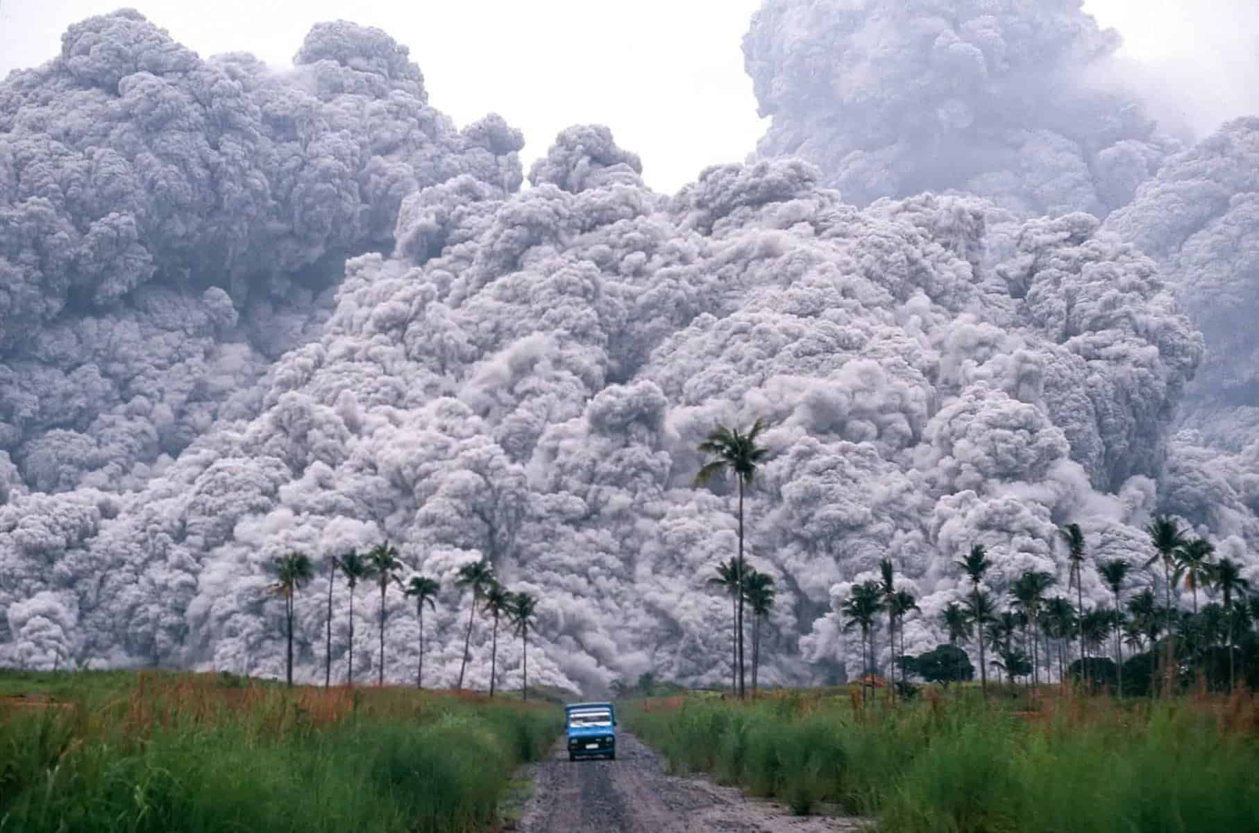
The people near the volcano had no idea that the earthquakes they were experiencing were signs that the volcano was coming to life. At 6pm on October 24th cinders and ashes started falling over the city of Quetzaltenango. By 8pm a plume of black ash covered the sky generating twisters and lighting the darkness with thousands of lightning bolts. Winds carried debris as far as 800km or more. By 1am the eruption grew stronger with large rocks and debris falling as far as 14km away from the eruption, destroying entire towns. The eruption continued until 12am October 26th.
Since the people had no warning of the eruption there were no evacuations and many areas faced complete devastation. At least 5,000 were killed in the eruption, 1,000 more were killed by the outbreak of Malaria that occurred as a result of the eruption. The devastation was made worse by the destroyed crops and the dying cattle. There were food shortages and people without homes but there was no assistance from the Guatemalan government except for being able to import flour free of taxes for a few months.

Nevado del Ruiz, Columbia 1985

Ten Worst Volcanic Eruptions of the 20th Century
wikipedia.org

The Nevado del Ruiz is an active volcano in Columbia that is known for creating lahars. This is largely due the amount of snow on top of the mountain that is often melted in the event of an eruption. The melted snow creates lahars which move quickly down the mountain to devastating effect. In November 1984 geologists began noticing more seismic activity around the mountain. Then on September 11th, 1985 there was an ash ejection which was the biggest sign of an impending eruption. A study on October 22nd 1985 found the that risk of lahars from an eruption was very high and local authorities performed some preparedness techniques.
On November 13th, 1985 Nevado del Ruiz started to erupt and ejected 35 million tons of material, including magma. The pyroclastic flow rushed over the landscape and melted the glaciers and snow at the summit. This created four very large and thick lahars that began racing down the river valleys at the back of the volcano at a speed of 60km per hour. The lahars consisted of ice, water, pumice, rocks and clay and they eroded soil and dislodged rocks as they traveled. Once they reached the river valleys that led away from the volcano the lahars quadrupled in size with one reaching a width of 50 meters.
One lahar was particularly devastating to the town of Armero which was located in the Lagunilla River valley. The entire town was erased and three quarters of the town’s 28,700 residents perished. There was nothing left of the town. Another lahar hit the town of Chinchina and killed 1,800 people and destroying 400 homes. In total from all of the lahars more than 23,000 people died, 5,000 were wounded and more than 5,000 homes were destroyed. The lahar is the deadliest of recorded history, the worst natural disaster in Columbia’s history and the fourth deadliest volcanic eruption in recorded history.

Mt. Pelee, Martinique 1902

Ten Worst Volcanic Eruptions of the 20th Century
http://www.historicalstockphotos.com/

St. Pierre, Martinique was called the “Paris of the Caribbean” it was a bustling city with a vibrant culture. It was on the coast and had a busy harbor and plenty of sugar and rum for export. But all of that came to an end in 1902. St. Pierre was located a mere 7 km from Mt. Pelee. There were small signs of an impending eruption but most were not understood by residents. There were small tremors in April 1902 and there were a few clouds of sulfurous fumes. Other than that, there was the mysterious appearance of a lake in the caldera and the break in an underwater telegraph cable.
Then on May 2nd, 1902 there was a small eruption. Those who saw it said that the top of the mountain seemed to catch fire and start spewing rocks. The mountain fumed for several days and people from the countryside near the volcano fled to St. Pierre. On May 5th, a lahar destroyed a sugar processing plant, killing 2 dozen people. Insects and vipers slithered down from the mountain, their delicate balance upset by the rumblings of the volcano. The serpents and bugs killed people and animals alike, even as soldiers patrolled the streets shooting the poisonous snakes.
On May 8th, the volcano erupted. Mt. Pelee shot hot gas and debris through the town of St. Pierre, killing everyone. Nearly every one of the 30,000 citizens were killed. One man survived because he was locked in an underground cell, one resident survived by making it onto a boat in the water and another just on the outskirts of town managed to live as well. The entire town was leveled with the debris cloud traveling at 100 m/s and the town was set ablaze for several days after the eruption. Ships burned and sank into the harbor and it was days before rescuers were able to come close enough to view the destruction. It was this eruption that led scientists to discover pyroclastic flow and its potential devastating effects.

Advertisement